
See Historic Aerial Photos Garden Home.
See 1936 Aerial Photos of Garden Home area by Army Corps of Engineers.
See Otto Arndt – 1950s Aerial Photos of Garden Home.
Below is a collection of aerial photos of Garden Home obtained using the USGS Earth Explorer. See the end of this post for more about USGS aerial photography. The earliest USGS aerial photos including Garden Home were taken in 1952. I arbitrarily stopped at 1975.

USGS EarthExplorer – Enter address or location to view
I’ve added selections from a 1936 aerial photo that Bob Cram obtained from the US Army Corps of Engineers, and from a 1943 aerial photo obtained from the City of Portland archives. I’ve also added some low-altitude photography and other images to provide context for the landmarks in the USGS aerial photos.

City Auditor – searching historical records – screenshot

US Army Corps of Engineers – requesting aerial photography – screenshot
Each USGS image caption contains a code like 1ZJ0000010118. These codes indicate which source file a cropped image came from. Some source images have been omitted due to size considerations.
Image resolution and quality varies greatly from year to year. Fortunately, the earliest images, 1952, have excellent resolution (54MB source files).
To view/download full size images, click on the image to open the image’s Attachment page. On the Attachment page, above the image, look for a link to the full-size image. Nearly all images have a higher resolution image available on their respective Attachment pages.

Viewing full-size images on an image’s Attachment page
Tom Shreve, 2023
Garden Home zoom
In the Garden Home zoom images below:
- SW Oleson Rd slashes diagonally from the lower left corner.
- SW Garden Home Rd runs horizontally across the bottom third of the image.
- The two roads running from the bottom-center of the frame and ending at SW Garden Home Rd are SW 71st Ave and SW 74th Ave.
- The Oregon Electric rail tracks enter from the right and split to exit the image at the top and bottom, with the original 1908 train station platform visible at the split.

1936 downtown Garden Home. Train station and platform visible just east of the future site of the cannery (Old Market Pub and Brewery). White Store visible (Dairy Queen). Walton’s Tavern is located just west of the Red Store (just west of the southbound tracks and south of Garden Home Road). The original 1912 school building remains unmodified. Gust Johnson’s Texaco original station building. The Community Church is just west of SW 71st Ave on SW Garden Home Rd.

1943 Garden Home zoom. The Oregon Electric station house has been moved to Beaverton, but the original platform trestle remains. The school has its first new addition and a few trees have been cleared. Roofless Seed & Feed has been built (it wouldn’t get a roof until 1957).

1952-07-02 1ZJ0000010117 Garden Home zoom. The Red Store stands but is no longer operating. The cannery has been built. The school added the long western building, and cleared many trees.

1954 Garden Home School from W – Arndt Neg 01.
From the Otto Arndt collection of low altitude photography of Garden Home and environs. Central Garden Home, Oleson Rd at an angle running left and right. School in foreground with the old original school building still attached in what is now the south parking lot. Garden Home Feed and Seed building has no roof structure. Community Church east of feed store at now SW 71st. Long 2-story store at the intersection, variously named Upchurch, Throckmortons or generally the White store, burned in 1956. Note the filbert orchard NE of intersection where Thriftway is built in 1957.

1954 – Aerial photo of site of Lamb’s Thriftway – Prior to construction – Arndt Neg 03

1957 – Aerial photo of Lamb’s Thriftway – Newly constructed prior to opening – Arndt Neg 08 detail. Seed and Feed roof is partially completed. Gust Johnson’s Texaco has a new building. White Store is an empty lot (it burned in 1956)

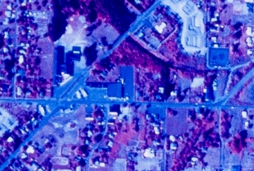
1960-08-01 1VACZ00010124 Garden Home zoom. Thriftway is open. The Red Store building still stands. The cafeteria expansion has been added to the school. The Community Church still stands just west of SW 71st. There are three gas stations at the intersection of SW Garden Home Rd and SW Oleson Rd.

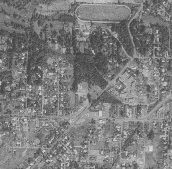
1970-07-08 1VCOA00010242 Garden Home zoom. The Community Church buildings have been moved to the Unitarian Fellowship on SW Oleson Rd. The original 1912 school building has been removed.

2023 Google Maps – Garden Home zoom
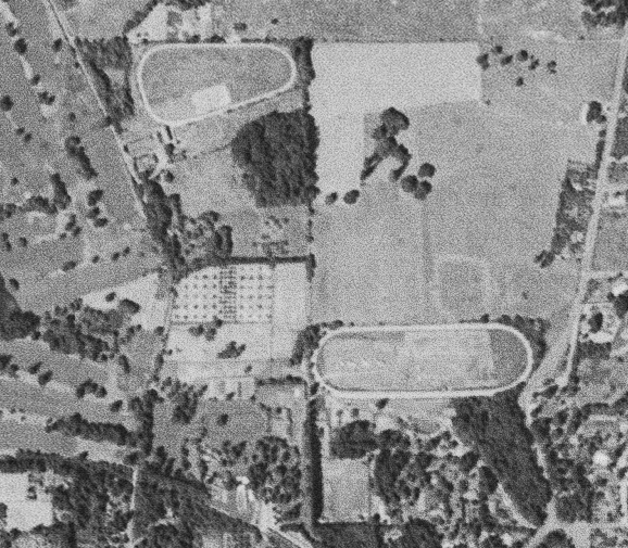
Frank Farm, Hunt Club, and riding academies

Frank track, stable and indoor riding arena

Frank buggy room

1940-06-15 Hunt Club – Ladies Classic at finish line. Mrs. Omer Bonney rode Sun Blanket to victory.

1940-06-15 Hunt Club – Omer Bonney stands next to his horse (Gold Dust) while holding a trophy, during the spring race meet for the Portland Hunt Club in Garden Home.
The Frank Farm, Hunt Club, and riding academies image-crop is characterized by:
- SW Oleson Rd runs north-south along the right edge, with a kink at the Hunt Club.
- SW Vermont runs east-west along the top edge.
- Nicol Riding Academy upper left.
- Shattuck Dairy upper left (now Arranmore).
- Hunt Club 1/4 mile oval center right (now OES), with Portland Riding Academy adjacent to the south-edge of the oval.
- Frank Farm’s stables are immediately west of the Portland Riding Academy stables.
- The Oregon Electric tracks arc through the lower left corner.
- Portland Golf Club begins along the left edge.

1936 Frank Farm, Hunt Club, and riding academies. SW Oleson Rd runs north-south along the right edge, with a kink at the Hunt Club. Nicol Riding Academy upper left. Shattuck Dairy upper left. Hunt Club 1/4 mile oval center right, with Portland Riding Academy adjacent to the south-edge of the oval. Frank Farm’s stables are immediately west of the Portland Riding Academy stables. The Oregon Electric tracks arc through the lower left corner. Portland Golf Club begins along the left edge.

1943 Hunt Club and riding academies. Since 1936, Nicol Riding Academy gained a couple buildings. The Frank Farm removed the train loading platform at the SW corner of their property.

1952-07-02 1ZJ0000010117 Frank Farm, Garden Home Hunt Club, and riding academies. Since 1943, the Nicol Riding Academy has built a paddock inside the track. A number of houses have been added to the Hunt Club.

1960-08-01 1VACZ00010125 Hunt Club and riding academies. Since 1952, significant suburban infill. It appears the Frank Farm has demolished the indoor riding area in the NE corner of the property.

1970-07-08 1VCOA00010241 Hunt Club and riding academies. Since 1960, the Nicol Riding Academy has been completely removed. Portland Riding Academy still exists, although Harry Kerron sold a chuck out of the middle upon which now stands a house.

1975-09-13 1VDYL00030130 Hunt Club and riding academies. The Hunt Club and Portland Riding Academy appear to still be operating. Arranmore and Oregon Episcopal School (OES) have not yet been developed.

2023 Google Maps – Frank Farm, Hunt Club and riding academies
Alpenrose
The left side of the image is Washington County, the right side is Multnomah County.

1936 Alpenrose

1943 Alpenrose

Alpenrose Dairy circa 1940s based on the two visible cars. Definitely pre-1952, because a 1952 aerial photo includes a new parking lot in the SE corner of complex.

1952-07-02 1ZJ0000010118 Alpenrose on right side of image (the right half of a shield-shaped area enclosed by roads and the Red Electric right-of-way along the north).

1955-08-17 1A001500081076 Alpenrose

1960-08-01 1VACZ00010124 Alpenrose

1970-07-08 1VCOA00010240 Alpenrose

1971-09-19 6184003904886 Alpenrose

1975-09-13 1VDYL00030130 Alpenrose (low resolution)

2021 Alpenrose aerial photo, courtesy of The Tribune
Greater Garden Home
Greater Garden Home in these cropped photos is roughly defined as south of Vermont, west of Multnomah County (SW 65th), north of SW Taylors Ferry Rd, and east of the Burgerville intersection. Sometimes the source images don’t cover the whole area, so I crop the best I can.
These are good images to click on, and then click on the link for the full-size image to really be able to zoom in. This section is also useful to determine at a glance which years have the best resolution (1936, 1943, 1952, 1960, 1970, 1971).

1936 greater Garden Home

1943 greater Garden Home. Garden Home was quite rural, with large tracts of yet to be developed land.

1952-07-02 1ZJ0000010118 greater Garden Home. The post-war housing boom was in full-swing in Garden Home.

1955-08-17 A001500081077 greater Garden Home. Fairly low resolution/blurry.

1960-08-01 1VACZ00010125 greater Garden Home

1970-07-08 1VCOA00010241 greater Garden Home

1971-09-19 6184003904872 greater Garden Home

1972-06-02 5720004211183 greater Garden Home. Low resolution/blurry.

1973-07-03 AR5730013110222 greater Garden Home. Low resolution/blurry.
1974-06-28 AR5740018400035 greater Garden Home. Low resolution/blurry.

1975-09-13 1VDYL00030131 greater Garden Home
1952
Comparing a 1936 aerial photo to the 1952 aerial photo, we see lots of houses were built in that period, many in the post-war boom.

1936 aerial photography of Garden Home and environs rotated and cropped to match 1952 image

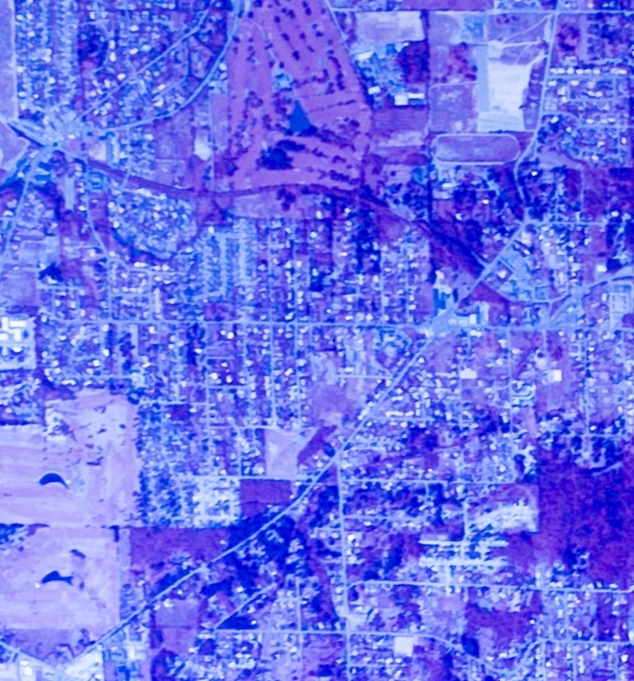
1952-07-02 1ZJ0000010117 Garden Home and Maplewood. Alpenrose top center. Portland Golf Club upper left quadrant. SW Multnomah Blvd enters mid-way down from the right.
1952-07-02 source photos
These source files are 55MB.
- 1ZJ0000010116 includes Maplewood, but Garden Home is out of frame.
- 1ZJ0000010117 and 1ZJ0000010118 have the best quality images of Garden Home.
- 1ZJ0000010137, 1ZJ0000010138, and 1ZJ0000010139 have slightly lower contrast images of Garden Home.


1955
The 1955 photos are much lower resolution than most other years.

1955-08-17 1A001500081076 Garden Home, Alpenrose, and Gabriel Park
1955-08-17 1A001500081076 Frank Farm, Hunt Club, and Portland Riding Academy
1955-08-17 source photos
These source images are over 75MB each, but they cover a huge area. Once cropped down to Garden Home, the files are low resolution.


1960

1960-08-01 1VACZ00010126 Garden Home

1960-08-01 1VACZ00010125 PGC, Garden Home, Maplewood, and Alpenrose

1960-08-01 1VACZ00010124 Garden Home, Alpenrose, and Maplewood. 1VACZ00010124 is the best resolution of the 1960-08-01 aerial photos.
1960-08-01 source photos
The source images are 66MB each.


1970
Some of the 1970 source files require rotation to align images to compass headings.

1970-07-08 1VCOA00010242 Garden Home (edge)
1970-07-08 1VCOA00010242 The cafeteria building has been added to the school, and the original 1911 school building has been demolished. There are three service stations at the main intersection. The Red Store building still stands kitty-corner to the cannery.

1970-07-08 1VCOA00010241 Garden Home and surrounding areas

1970-07-08 1VCOA00010240 Garden Home

1970-07-08 1VCOA00010181 Maplewood and Gabriel Park

1970-07-08 1VCOA00010180 Maplewood and Gabriel Park
1970-07-08 source photos
These source images are 66MB each.


1971

1971-09-19 6184003904944 Garden Home

1971-09-19 6184003904943 Garden Home and Gabriel Park

1971-09-19 6184003904886 Garden Home
1971-09-19 6184003904886 Three service stations

1971-09-19 6184003904873 Garden Home – PGC and Progress Downs (now Red Tail Golf Course)

1971-09-19 6184003904872 Garden Home

1971-09-19 6184003904887 Garden Home zoom
1972
Source files require rotation to align images to compass headings.

1972-06-02 5720004211183 greater Garden Home

1972-08-10 5720005514565 Garden Home

1972-08-10 5720005514564 Garden Home
1973
Source files require rotation to align images to compass headings.

1973-07-03 AR5730013110221 Garden Home

1973-07-03 AR5730013110222 Garden Home and surrounding areas
1974
Source files require rotation to align images to compass headings.

1974-06-28 AR5740018400035 greater Garden Home

1974-06-28 AR5740018400036 Garden Home
1974-06-28 source photos


1975

1975-09-13 1VDYL00030130 Garden Home

1975-09-13 1VDYL00030131 Garden Home
1975-09-13 1VDYL00030131 zoom
Better and best among source files
Within a set of aerial photos for a particular date, typically five to ten photos, some source photos may be better than others. As the plane flew overhead, it may take three photos that include Garden Home (say, in the top half of the frame), and then later another parallel pass that also includes Garden Home (say, in the bottom half of the frame). Lighting conditions may vary between passes. Within a single pass, one photo is likely to have Garden Home closer to the center of the camera lens than the others. This is all to say that for a particular year, I try to use only the best source photo(s).
The first step was to examine each set of source files and determine the better and best of the source images for particular year, and then work from there. Sometimes it mattered how close Garden Home was to the center of the source image because the source image required rotation to align north and south, which often complicates subsequent cropping.
Sometimes, there are quality differences among the source files for a particular year. For example, of the seven 1952 source photos, 1ZJ0000010117 and 1ZJ0000010118 stand out as the highest quality. See below:
1952-07-02 1ZJ0000010117 Garden Home zoom. Gust Johnson’s Texaco original station building, White Store, roofless Seed & Feed, Community Church, defunct Red Store, and Whitney’s Cannery. The cafeteria building hasn’t been added to the school yet.

1952-07-02 1ZJ0000010118 Garden Home zoom. Approximately the same contrast/fidelity compared to 1952-07-02 1ZJ0000010117. It’s difficult to differentiate these two source files.

1952-07-02 1ZJ0000010137 Garden Home zoom. Slightly lower contrast than 1ZJ0000010117 and 1ZJ0000010118.

1952-07-02 1ZJ0000010138 Garden Home zoom. This image is the worst of the 1952-07-02 aerial photos.

1952-07-02 1ZJ0000010139 Garden Home zoom. Visibly worse quality than 1ZJ0000010117 or 1ZJ0000010118.
About USGS historic aerial photography
USGS (United States Geologic Service) has aerial photography spanning back to 1952. Use the EarthExplorer.USGS.gov web application to view aerial photography. Downloading high-resolution images requires registering and creating an account, free, but it takes a couple of minutes to register. You must log in to download images. Finding and downloading historic aerial imagery is a little confusing at first, so I’ve created a brief step-by-step tutorial below.
-
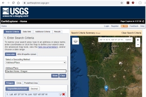
- Enter address or location to view
-

- Select address result
-
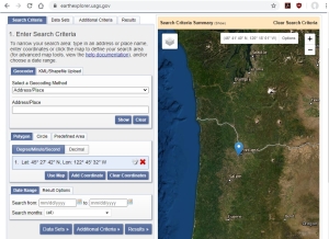
- click Select Data Sets
-
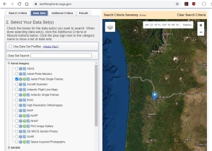
- select Aerial Imagery, Aerial Photo Single Frames
-
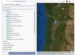
- click Results button
-
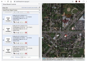
- click Last to see oldest results first, click thumbnail to view (don’t worry if thumbnail says Image Not Available)
-
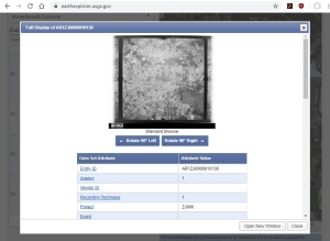
- displays low res photo, click Open New Window
-
- scroll down to bottom of the new window, click Download
-
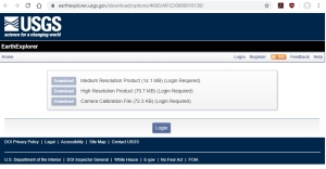
- download desired resolution (or click Register to create an account)

Very well done. Interesting how the gradual changes occurred over time.
Thanks
Stanley E Houseman 503 679-3691 Community Connections and Consultant
Thanks Stan. The next project is to lay 1936 and 1952 side-by-side.
Pingback: November 2023 UPDATE – Garden Home History | Garden Home History Project
Pingback: Otto Arndt – 1950s Aerial Photos of Garden Home | Garden Home History Project